
Misinterpreting property lines can lead to costly disputes over docks, structures, and setback violations, turning a dream lakefront property into a legal nightmare. For buyers and sellers in the Brainerd Lakes area, knowing exactly where your land ends and public water begins is not just a detail—it’s a critical component of your investment. Understanding how to verify property lines for lakefront real estate in Minnesota is essential for protecting your investment, ensuring compliance with local regulations, and maintaining good relationships with your neighbors. In this blog post, Nisswa real estate expert Dan Schueller discusses how to verify property lines for lakefront real estate, drawing on nearly 39 years of experience with waterfront property in North Central Minnesota.
Key Takeaways
- Property verification is a multi-step process, combining document review, digital mapping, and physical inspection, with a professional survey providing final legal certainty
- Lakefront properties have unique boundaries governed by Minnesota’s Ordinary High Water Level (OHWL) rules, which are different from standard lot lines
- A professional survey is essential for legal protection, providing the certified boundaries required for construction permits, dispute resolution, and real estate transactions
- Local resources are key, and knowing which county offices and DNR departments to contact can streamline the verification process in the Brainerd Lakes area
To verify property lines for lakefront real estate in Minnesota, start by reviewing your property deed and plat map from the county recorder’s office. Next, use county GIS mapping systems for a preliminary overview, and then search for physical survey markers at your property’s corners. For lakefront properties, it’s crucial to understand that the Ordinary High Water Level (OHWL) determined by the Minnesota DNR often establishes your legal water boundary. For absolute legal certainty before construction or during a sale, hiring a licensed Minnesota land surveyor is the most reliable step.
To Discuss Your Home Sale or Purchase, Call or Text Today and Start Packing!
Start with Essential Property Documents
The first step in verifying your property lines is to gather and understand your foundational legal documents: the deed and the plat map. These documents contain the official legal description of your property’s boundaries. You can typically obtain a copy from the County Recorder’s office in the county where the property is located, such as the Crow Wing or Cass County offices for many Brainerd Lakes properties. The legal description is the most critical piece of information, outlining the specific dimensions and location of your land.
Understanding the legal description can be challenging, as it often uses specific terminology. Your property might be described using a “metes and bounds” system, which details a starting point and traces the boundary using directions and distances. Alternatively, it may use a “lot and block” description, which is more common in subdivided areas and references a recorded plat map. In Minnesota, it’s also important to know if your property is under the Torrens system, where a Certificate of Title provides a government-guaranteed record of ownership and boundaries.
A thorough review of these documents provides the official basis for your property lines. It’s the starting point from which all other verification methods, including physical surveys, are derived. When examining your deed and plat map, look for specific measurements for each boundary line, references to monuments or permanent markers, easements or rights-of-way that may affect your property use, and the official subdivision name and lot number. The top realtor in Nisswa can help you interpret these documents and understand what they mean for your lakefront property investment.
Using Digital Tools and Finding Physical Markers
Once you have your legal documents, you can use online tools for a preliminary visual check. Most Minnesota counties, including Crow Wing and Cass, offer public Geographic Information System (GIS) mapping websites. These tools overlay property parcel lines onto aerial photographs, providing a helpful but non-binding visual representation of your property. While extremely useful for getting a general idea, it is critical to remember that GIS maps are for informational and tax purposes only and are not legally binding surveys.
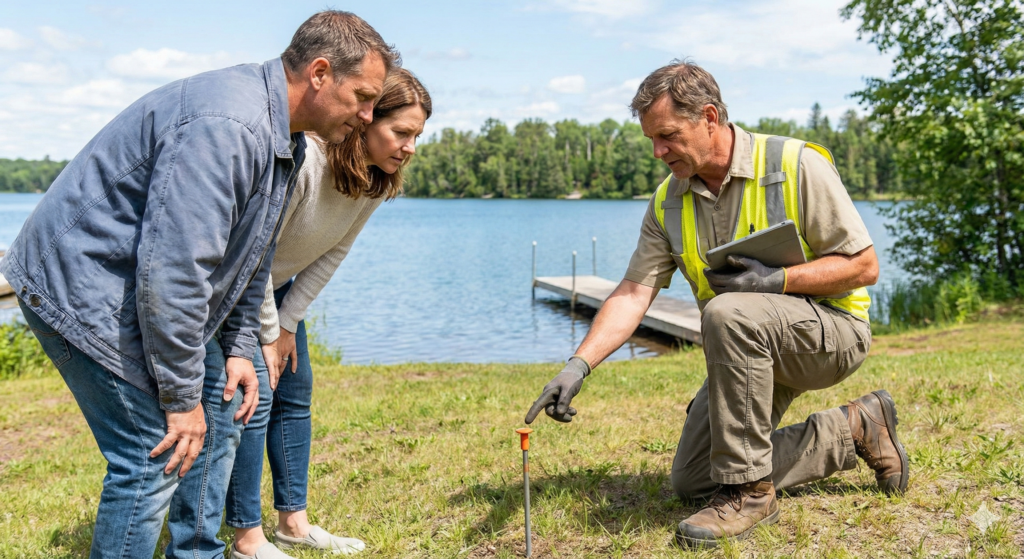
The next step is to search for physical survey markers, also known as monuments or pins, on the property itself. In Nisswa, these are typically iron pipes or rods driven into the ground at the corners of a property. They can be difficult to find, often buried several inches or even a foot below the surface due to soil shifts, landscaping, or erosion, which is common on lakefront land. Renting a metal detector from a local hardware store can be an effective way to locate these buried markers.
Walking your property lines while looking for these markers helps you develop a practical understanding of your boundaries. However, it’s important to recognize that even if you find existing pins, they may have been moved over time by natural forces or human activity. Digital mapping combined with physical marker identification gives you a strong preliminary understanding, but neither method replaces the legal certainty of a professional survey, especially when you’re preparing to sell your home in Nisswa or make significant improvements to your lakefront property.
“Finding existing survey pins can give homeowners peace of mind, but it doesn’t replace a professional survey. Over the years, pins can be moved or disturbed. For any significant action, like building a garage or selling the property, getting a fresh survey is the only way to ensure legal accuracy and protect yourself.” – Dan Schueller
The Lakefront Difference: Minnesota’s OHWL and Riparian Rights
Verifying property lines for lakefront real estate in Nisswa real estate and across Minnesota involves unique rules that don’t apply to inland properties. The most important concept is the Ordinary High Water Level (OHWL). The Minnesota Department of Natural Resources (DNR) defines the OHWL as the boundary between public waters and private land. This is not the current water’s edge, which fluctuates, but a determined elevation based on physical evidence like changes in vegetation, soil type, and natural debris lines. Your property ownership extends to the OHWL, and the state owns the land below it.
This distinction is crucial because it affects what you can do with your shoreline. Understanding your OHWL is necessary for placing docks and boat lifts legally, planning shoreline restoration projects, determining setbacks for new construction, and understanding your property tax assessment. In addition to the OHWL, lakefront owners have “riparian rights,” which are the rights to use the water, such as for boating, swimming, and fishing. These rights also include the right to access the water from your property.
Your side property lines are generally understood to extend into the lake at a right angle from the shoreline, defining your area of riparian use. Disputes can arise when a neighbor’s dock or swim raft encroaches into your riparian space, making a clear understanding of these projected lines essential. For those considering homes for sale in Nisswa on popular lakes like Gull Lake, Crosslake, or the Whitefish Chain, understanding these lakefront-specific boundary rules is a critical part of due diligence that protects your investment and prevents future conflicts.
Minnesota Lakefront Property Lines
Understanding OHWL, Riparian Rights, and Ownership
Common Questions
A DIY property line search (reviewing deeds/markers) provides a preliminary idea but lacks legal authority. A professional survey by a licensed Minnesota land surveyor establishes exact boundaries with certified accuracy, including the critical Ordinary High Water Level (OHWL). For legal disputes, building permits, or selling, only a Certificate of Survey is accepted as definitive proof.
The Professional Survey: Your Ultimate Legal Proof
While reviewing documents and using GIS maps are valuable preliminary steps, the only way to definitively and legally verify your property lines is to hire a licensed Minnesota land surveyor. A professional survey provides a legally binding determination of your property’s boundaries, including the critical OHWL for lakefront parcels. This is an essential step before any construction, during a boundary dispute, or when buying or selling high-value North Central Minnesota real estate.
A surveyor will research your property’s legal history, locate existing monuments, and use precise equipment to measure and mark your boundaries. They will then produce a Certificate of Survey, a legal document that officially records your property lines. The cost and timeline for a survey can vary based on several factors. The size and complexity of the property, the density of vegetation, the season, and the surveyor’s workload all play a role. For lakefront properties, determining the OHWL may add to the cost. In the Brainerd Lakes area, a standard boundary survey might cost between $800 and $2,000, while more complex surveys can be higher.
Despite the cost, a professional survey is a worthwhile investment that provides legal certainty and prevents future issues. It’s particularly important when you’re about to build structures like garages, boathouses, or decks that must comply with setback requirements. Furthermore, having a recent survey available when you list your lakefront property gives potential buyers confidence and can expedite the closing process. Many lenders and title insurance companies require a current survey for lakefront properties, making this investment virtually mandatory for most transactions.
“I always recommend that sellers commission a new survey before listing their lakefront property, especially if the last survey is more than ten years old. It eliminates surprises during the transaction and gives buyers the certainty they need. In my experience, properties with current surveys sell faster and with fewer complications.” – Dan Schueller
Survey Costs
| Survey Type | Average Cost Range | Typical Timeline | Best Use Case |
|---|---|---|---|
| Boundary Survey | $800-$2,000 | 1-3 weeks | Standard property line verification |
| OHWL Determination | $500-$1,200 | 1-2 weeks | Waterfront boundary certification |
| Topographic Survey | $1,500-$3,500 | 2-4 weeks | Construction planning and drainage design |
| ALTA/NSPS Land Title Survey | $2,000-$5,000 | 3-6 weeks | Commercial transactions and title insurance requirements |
Why Choose Dan Schueller to Help With Your Lakefront Property
Navigating the complexities of lakefront property lines is just one part of buying or selling a home on the water. When you need to sell your home in Nisswa or purchase your dream lake cabin, working with a specialist who understands these nuances is crucial. With nearly 39 years of experience in Nisswa real estate, Dan Schueller has built a reputation as the top realtor in Nisswa for lakefront properties. His team at Your Home Sold Guaranteed Realty Exclusive has an unmatched understanding of the Gull Lake, Crosslake, Whitefish Chain, Pelican Lake, Leech Lake, and Mille Lacs Lake markets.

This deep expertise is backed by a track record of success and hundreds of 5 Star Google reviews. The team sells over 100 homes a year, leveraging a database of 17,000 pre-qualified buyers to connect sellers with the right buyers quickly. Furthermore, unique programs like the Guaranteed Sale Program offer clients peace of mind that their property goals will be met. The team typically sells homes for 10% more than market average, which on a $400,000 lakefront property means an extra $40,000 in your pocket, while also selling 70% faster than other local realtors.
Understanding property boundaries is just one of many technical aspects that require specialized knowledge when dealing with lakefront real estate. From DNR regulations to riparian rights to OHWL determinations, the complexity of waterfront property transactions demands an experienced guide. With Your Home Sold Guaranteed Realty Exclusive‘s comprehensive understanding of these issues and commitment to protecting your investment, you can navigate your lakefront property transaction with confidence. All incentives and guarantees must be agreed upon and in writing. To discuss your home sale or purchase, call or text Dan Schueller today at (218) 656-6469 and Start Packing!
Follow Us on Social Media
Follow Your Home Sold Guaranteed Realty Exclusive on social media for the latest Brainerd Lakes area real estate insights, lakefront property market updates, and North Central Minnesota listings. Connect with us on YouTube, Facebook, Instagram, and TikTok for exclusive content and expert guidance.
FAQ
What’s the difference between a DIY property line search and hiring a professional surveyor for my Minnesota lakefront property?
A DIY property line search, which involves reviewing your deed, using county GIS maps, and looking for physical markers, provides a valuable but non-binding preliminary understanding of your boundaries. It’s a great starting point for general knowledge and costs nothing beyond your time. However, it lacks legal authority and precision. A professional survey conducted by a licensed Minnesota land surveyor is a legally defensible process that establishes your exact boundaries with certified accuracy.
For lakefront properties, this is especially critical, as surveyors can also help determine the Ordinary High Water Level (OHWL), which defines your property’s limit at the shoreline. While DIY research is free, a professional survey is a necessary investment for legal certainty before you build, when you buy or sell, or if a dispute arises with a neighbor. The Certificate of Survey provided by a licensed surveyor is the only document that courts and government agencies will accept as definitive proof of your property boundaries.